
Check Blue Ridge Parkway Conditions Before You Go |
Article Sub Headline |
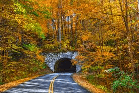 |
The Blue Ridge Parkway is one of the easiest ways to turn an ordinary day in Western North Carolina into a mountain outing. But before heading out for a drive, hike, picnic, or overlook stop, Asheville-area residents should make one quick habit part of the plan: check the official Parkway road status first.
The National Park Service road-status page was updated the morning of June 9 and still showed some closures along the Parkway, including Helene-related closures around Little Switzerland and NC 80. That means some routes may not be available even if they look open on a map.
For local drivers and weekend explorers, this matters. A closed stretch of the Parkway can turn a simple scenic drive into a long detour, especially in mountain areas where alternate routes may be narrow, winding, or time-consuming. Trailhead access, picnic areas, overlooks, and connecting roads can also be affected by temporary closures, maintenance work, storm recovery projects, rockslides, fallen trees, or changing weather conditions.
The practical takeaway is simple: check before you leave. The Parkway is beautiful, but conditions can change quickly from one section to another, especially at higher elevations. A clear morning in Asheville does not always mean the route you planned is open or safe.
A few smart planning tips:
The Parkway remains one of the region’s most beloved outdoor assets, but a little planning goes a long way. Whether you are heading toward Craggy Gardens, Mount Mitchell, Little Switzerland, or a favorite overlook, start with the official road status and adjust from there.
For Asheville-area readers, this is one of those small reminders that can save time, reduce frustration, and make a mountain day safer and more enjoyable. |